
Essential Destination Profile: Galiyat Region: Colonial Hill Stations, Pine Ridges & Alpine Trails
About Galiyat Region: Colonial Hill Stations, Pine Ridges & Alpine Trails
The Galiyat (or Galyat) region is an enchanting, pine-forested sub-Himalayan mountain corridor stretching along the high mountain ridge between Murree and Abbottabad in Khyber Pakhtunkhwa. Perched at elevations between 2,100 metres and 2,992 metres, this celebrated chain of colonial-era hill stations ("Galis") offers cool mountain air, dense virgin canopies of Himalayan blue pine (Pinus wallichiana) and silver fir (Abies pindrow), and breathtaking panoramas overlooking the forested gorges of the Jhelum and Haro river basins. Centered around the famous mountain retreats of Nathia Gali, Donga Gali, Changla Gali, and the protected wildlife sanctuary of Ayubia National Park, the Galiyat serves as northern Pakistan's premier and most accessible year-round mountain retreat.
Galiyat Travel Logistics & Alpine Ridge Snapshot
- Proximity & Easy Access: Situated just 75 km to 95 km north of Islamabad and Rawalpindi (1.5 to 2.5 hours drive) via the four-lane Murree Expressway (N-75) or via the Hazara Motorway (M-15) through Abbottabad.
- Ridge Elevation Profile: Main hill resort towns sit at 2,100m to 2,500m; Mukshpuri Peak rises to 2,800m (9,200 ft); and the monarch of the range, Miranjani Peak, crowns the entire ridge at 2,992m (9,816 ft).
- Three Signature Ridge Trails: The flat, family-friendly 4km historic Pipeline Track (1899) between Donga Gali and Ayubia; the subalpine wildflower meadow ascent of Mukshpuri; and the alpine pine forest ridge hike to Miranjani.
- Protected Wildlife Sanctuary: Ayubia National Park spans 3,312 hectares of moist temperate coniferous forest, safeguarding common leopards, Asiatic black bears, red giant flying squirrels, and over 200 bird species.
- Year-Round Mountain Climate: Refreshing summer temperatures (18°C–24°C) escaping city heat; romantic monsoon cloud inversions in July and August; and deep winter snowfalls from December through February.
- Colonial Architecture & Heritage: British-era timber-framed churches (St. Matthew's in Nathia Gali, built in 1914), historic stone Governor Houses, vintage forest rest houses, and the iconic Ayubia chairlift.
Established during the mid-19th century as summer sanitaria and cantonments for colonial administrators seeking refuge from the sweltering heat of the Punjab plains, each "Gali" developed its own distinctive character, elevation, and atmosphere.
Comprehensive Town-by-Town Guide to the Galiyat
Understanding the unique character of each Gali allows travelers to choose the ideal base for relaxation, hiking, or family stays:
| Hill Station / Town | Elevation | Travel Character & Best For | Signature Landmarks & Trails | Stay & Dining Options |
|---|---|---|---|---|
| Nathia Gali | 2,500m (8,200 ft) | Administrative and tourism capital of Galiyat; vibrant, scenic, and active | Governor House, St. Matthew's Church, Lalazar Park; trailheads for Miranjani and Mukshpuri | 4-star mountain resorts, boutique alpine chalets, cliffside cafes, and traditional bazaars |
| Donga Gali | 2,500m (8,200 ft) | Quiet, forested nature hub nestled directly beneath Mukshpuri ridge | Starting point of the flat 4km Pipeline Track; northern meadow ascent to Mukshpuri Peak | Restful boutique lodges, historic Forest Department rest houses, and quiet woodland cafes |
| Ayubia | 2,100m – 2,400m | Family recreation and wildlife sanctuary centered on Ayubia National Park | Ayubia chairlift, wildlife interpretation museum, Pipeline Track terminus, and guided nature trails | PTDC motel, family lodges, local restaurants, and recreational park facilities |
| Changla Gali & Khaira Gali | 2,560m (8,400 ft) | Highest motorable road crest in southern Galiyat; sweeping valley vistas | Vantage points overlooking the Murree hills, Jhelum River gorge, and snow-capped Kashmir ridges | Scenic roadside viewpoint hotels, local fruit stalls, and tea terraces |
| Thandiani | 2,700m (8,860 ft) | Secluded, untouched northern outpost meaning 'Very Cold'; serene wilderness | Pristine deodar groves, terminus of the 2-day Dagri Bangla wilderness ridge trek from Nathia Gali | Peaceful woodland guest houses, camping grounds, and rustic tea stalls |
Seasonal Planning Guide: Weather, Packing & Road Conditions
The Galiyat is a true four-season mountain corridor, with each season offering distinct highlights and practical travel considerations:
- Spring (April to May): Daytime temperatures range between 15°C and 20°C. Snow melts from high ridge crests, triggering vibrant blooms of wild anemones, primulas, and gentians. Ideal for peaceful hiking before summer holiday crowds arrive. Pack light woolens and windbreakers.
- Summer (June to August): The primary high season with pleasant daytime temperatures around 18°C to 24°C. July and August bring the southwest monsoon, wrapping the pine ridges in dramatic rolling mist and ethereal cloud inversions. Trails can be damp and mossy—carry sturdy waterproof footwear, rain jackets, and an umbrella. Leeches may occur on damp forest trails during heavy rains.
- Autumn (September to November): Widely regarded by photographers as the finest season. Skies turn sapphire-blue, air becomes crisp and dry, and horse chestnut and oak canopies shift to brilliant golden-amber hues. Exceptional long-distance visibility reveals the distant snow mass of Nanga Parbat (8,126m) from high ridge summits. Warm layers and thermal fleece are required for cold evenings (6°C to 12°C).
- Winter (December to March): Heavy snowfall blankets the region with 3 to 6 feet of snow, transforming Nathia Gali and Ayubia into a winter wonderland. The main Murree-Abbottabad Highway is routinely cleared by Khyber Pakhtunkhwa Highway Authority machinery. Winter driving tip: Travelers must carry tyre snow chains, inspect vehicle anti-freeze, and watch for early-morning black ice between Sunny Bank and Donga Gali. Hot room heaters and warm winter parkas are mandatory.
Connecting the 3 Signature Galiyat Trails in One Weekend
Travelers planning a weekend escape from Islamabad can experience the best walking routes across the Galiyat ridge in a seamless sequence:
- The Gentle Warm-Up: Begin on Saturday morning with the flat 4km Pipeline Track from Donga Gali to Ayubia (1.5 to 2 hours of easy shaded walking beneath towering pine boughs).
- The Meadow Panorama: On Saturday afternoon, ascend the rolling subalpine wildflower slopes of Mukshpuri Peak (2,800m) from Nathia Gali or Donga Gali (2.5 to 3 hours round-trip) for sunset over the Pir Panjal range.
- The Summit Crown: On Sunday morning, tackle the forested ridge trail to Miranjani Peak (2,992m) (4 to 5 hours round-trip), standing at the highest elevation in the district before descending to Nathia Gali for a celebratory lunch.
For international visitors and travelers looking to combine forest hiking, boutique mountain lodges, and private 4x4 transfers, explore our tailored Custom Pakistan Tours for personalized Galiyat weekend escapes.
Key Highlights & Geographic Significance
Featured Valleys, Places & Attractions in Galiyat Region: Colonial Hill Stations, Pine Ridges & Alpine Trails
Miranjani
Miranjani destination profile and travel guide.
Mushkpuri
Mushkpuri destination profile and travel guide.
Donga Gali
Donga Gali destination profile and travel guide.
Pipeline Track Ayubia to Donga Gali
Pipeline Track Ayubia to Donga Gali destination profile and travel guide.
Tours & Treks in Galiyat Region: Colonial Hill Stations, Pine Ridges & Alpine Trails
Handcrafted guided departures, private 4x4 road journeys, and alpine trekking routes exploring Galiyat Region: Colonial Hill Stations, Pine Ridges & Alpine Trails and the wider Khyber Pakhtunkhwa mountain corridor.
 Tour Package 5 Days / 4 Nights
 5-Day Swat, Kalam & Malam Jabba Scenic Tour Package
Discover Pakistan's 'Switzerland of the East' on our signature 5-day private tour. Ride the chairlifts at Malam Jabba ski resort, explore ancient Gandhara Buddhist stupas, and take a 4x4 jeep safari through Ushu Forest to turquoise Mahodand Lake.
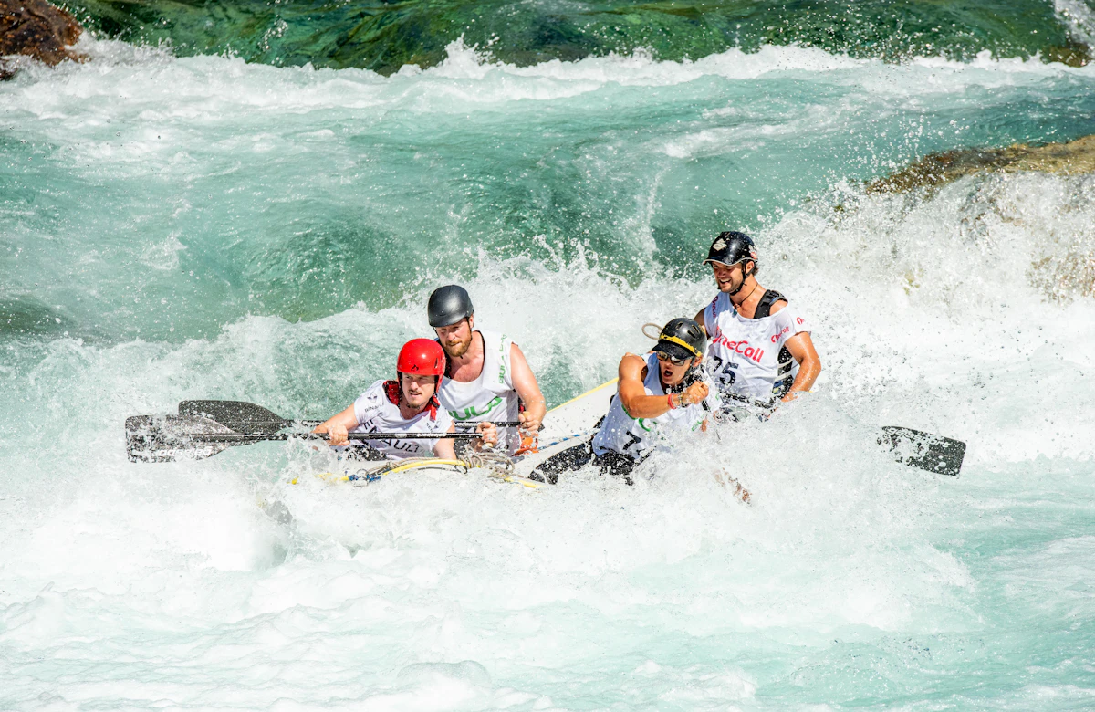 Tour Package 1-Day Day Trips to 3-Day Weekend River Expeditions
 Whitewater Rafting in Pakistan: Glacial Rapids on Kunhar, Indus, Neelum & Swat Rivers
Conquer exhilarating Grade II to IV+ glacial rapids on Pakistan's premier river runs: the foaming Kunhar River in Kaghan, the emerald Swat River, pine-lined Neelum River in Kashmir, and massive big-water gorges of the upper Indus near Skardu.
 Trekking Route 2 to 3 Days Wilderness Trek
 Dagri Bangla Deep Forest Wilderness Trek (2,720m): The Great Galiyat Pine Traverse
Trek deep into the mystical temperate rainforests of Ayubia National Park to Dagri Bangla (2,720m), a historic 1927 British colonial forest lodge surrounded by centuries-old blue pines, leopard sanctuaries, and complete alpine seclusion.
Trekking Route 3 Days / 2 Nights Galiyat 3-Trek Alpine Challenge: Mushkpuri, Miranjani & Pipeline Track (3 Days)
Conquer Galiyat's three most celebrated alpine trails in a single weekend: summit Miranjani Peak (2,992m), ascend the wildflower meadows of Mushkpuri Top (2,800m), and stroll the historic 1891 Ayubia Pipeline Track.
Design a Custom Galiyat Region: Colonial Hill Stations, Pine Ridges & Alpine Trails Itinerary
Have specific dates, private group preferences, or combining multiple valleys across Khyber Pakhtunkhwa? Our mountain logistics desk crafts tailored private 4x4 departures.
- Private 4x4 Toyota Prado / Land Cruiser convoy
- Certified local mountain guides & porters
- Curated heritage lodges & boutique camps
Frequently Asked Questions About Galiyat Region: Colonial Hill Stations, Pine Ridges & Alpine Trails
What is the best way to travel to the Galiyat from Islamabad?
The Galiyat region is easily accessible from Islamabad/Rawalpindi in approximately 1.5 to 2.5 hours. Travelers drive along the four-lane Murree Expressway (N-75) to Sunny Bank (Murree), then follow the scenic Murree-Abbottabad Highway northward through Changla Gali, Ayubia, Donga Gali, and Nathia Gali. Alternatively, travelers can take the Hazara Motorway (M-15) via Havelian and Abbottabad, approaching Nathia Gali from the north.
How do I choose where to stay between Nathia Gali, Donga Gali, and Ayubia?
Nathia Gali is the primary tourism hub, offering the widest range of boutique luxury hotels, cliffside dining, and central access to both Miranjani and Mukshpuri trailheads. Donga Gali is ideal for travelers seeking tranquility, dense pine forests, and immediate access to the Pipeline Track. Ayubia is tailored for families with children who want to visit the national park, chairlift, and recreational grounds.
What are the three most famous hiking trails in the Galiyat?
The three premier trails are: 1) The Pipeline Track (a flat, easy 4km family nature walk between Donga Gali and Ayubia), 2) The Mukshpuri Peak trek (a moderate 3-hour round-trip hike to a 2,800m subalpine meadow summit), and 3) The Miranjani Peak trek (a moderate-to-strenuous 4 to 5-hour round-trip hike to the highest point in the Galiyat at 2,992m).
Can you hike the Pipeline Track, Mukshpuri, and Miranjani in a single weekend trip?
Yes. A very popular weekend itinerary from Islamabad involves walking the gentle 4km Pipeline Track on Saturday morning, hiking Mukshpuri Peak on Saturday afternoon for sunset, and summiting Miranjani Peak on Sunday morning before driving back to Islamabad.
Is the Galiyat accessible during the winter snow season?
Yes. The Galiyat receives substantial snowfall from December to late February, transforming the pine ridges into a winter wonderland. The main Murree-Abbottabad highway is regularly cleared by heavy machinery. However, travelers visiting in winter should drive vehicles equipped with tyre snow chains, carry anti-freeze coolant, and check road updates with local highway authorities following heavy snowstorms.
What wildlife lives in Ayubia National Park?
Ayubia National Park protects a rich Himalayan moist temperate ecosystem. Wildlife includes the common leopard, Asiatic black bear, yellow-throated marten, red flying squirrel, and rhesus macaque monkeys. Birdwatchers can spot over 200 avian species, including the koklass pheasant, kalij pheasant, Himalayan griffon vulture, and red-billed blue magpie.